Manoeuvring Feasibility Analysis Fraser River Jet Fuel Dock, Colombie-Brittanique
2022
Client(s) : Moffatt & Nichol and FSM Group
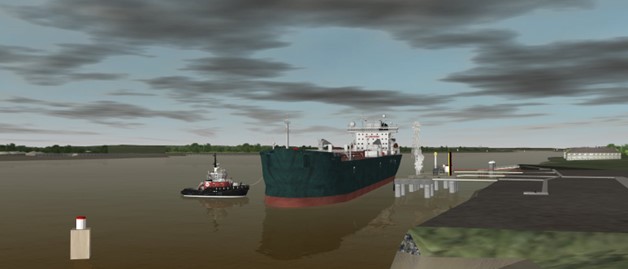
A new terminal facility was built on Lulu Island, south of Vancouver airport for the purpose of receiving jet fuel. This simulation analysis was undertaken at the request of Moffatt and Nicol to evaluate berthing and unberthing operations of Articulated Tug and Barge Units (ATBs) and PANAMAX-size tankers at the new Vancouver Airport Jet Fuel Dock. It also provided an opportunity for the pilots to identify in some detail considerations for escort training procedures, both for the pilots and tug masters from the designated towing company. Simulation analyses of this type have become standard practice within the pilotage jurisdiction of the Pacific Pilotage Authority (PPA) and the limits of the Vancouver Fraser Port Authority (VFPA) for any new terminal developments, existing terminal expansions or modifications, or at any time a vessel of significantly different size or manoeuvring characteristics intends to call upon an existing terminal.
MSRC’s own database development tool was used to create a high-fidelity 3D geographical area model of the dock, which was added to the existing model of the Fraser River. The 3-D area model included all aspects of the channel bathymetry and shore-side structures. The MSRC has also compiled other area models for numerous customers around the world. Electronic Navigation Charts were used for georeferencing all pertinent aspects of marine navigation: bathymetric contours (including drying areas), spot soundings, terrain elevation, coast line, and man-made structures. Satellite imagery and local photography were used extensively to ensure that the visual scenery yielded an accurate area representation including non-charted fixtures commonly used by experienced pilots.
Given the importance of the combined tidal and river currents on vessel navigation, and the seasonal variations that occur in river level/outflow volumes, comprehensive 3-D water flow models were used in order to conduct simulation runs during normal river level and freshet outflow conditions, as well as falling and rising tide conditions.